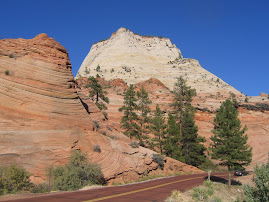
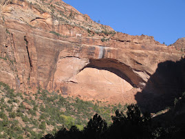
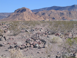
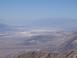
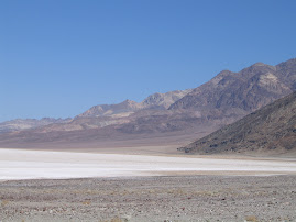
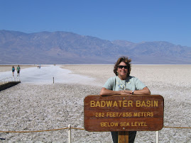
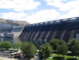
Death Valley that is. We explored the northern half of the valley yesterday. To get there we had to cross the last ridge of the Sierra and head on a long down hill glide. The northern section only goes as low as sea level. We travelled across and then north to a mansion/museum called Scottie's Mansion. It was the summer home of a wealthy midwestern millionaire who befriended a shameless promoter of the Death Valley area. The ride is through country as severe as we've seen. How anything grows here is amazing, but stuff still manages to take hold. The mansion tour is interesting.
I'd planned to take a different route home on roads shown on some local maps. The park personell talked me out of it. They said that only an expert four- wheeler should attempt it. After our excursion at Yosemite, I put myself in that class and was ready to go. Then I turned around and saw Dana about to pass out and decided to go back the way we came. I really hate doing that.
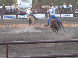
Today's a chore day and football day.
Sunday, September 30, 2007
Saturday, September 29, 2007
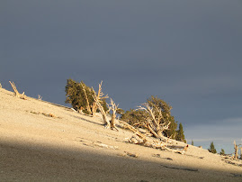
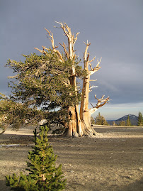
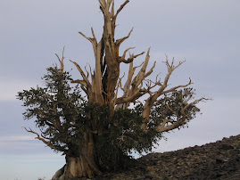
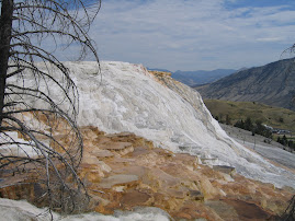
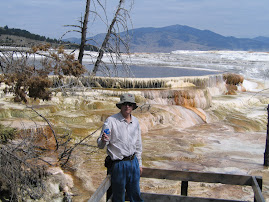
Ancient Bristlecone Pines
We drove down around the southern end of the Sierra Nevada Range and then back up to the town of Lone Pine, Ca. It's really in the middle of nowhere. Mt. Whitney is just to our west and Death Valley just east and south. The highest and lowest within 100 miles of each other. After a difficult set up, we had lunch and decided to drive the 72 miles north and east to the White Mountains. These are also part of the Sierra although a valley runs between them and Mt. Whitney.
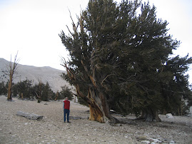
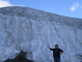
We had discussed running down to Joshoa Tree National Park because I believed that the Bristlecone Pines were there. Bristlecones are the oldest known living things on earth. A little research revealed that no Bristlecones are found in Joshoa Tree Park. Joshoa Trees are found there. Bristlecones are found mainly in the White Mountain area. They live in an environment where little competition exists. About 10,000 feet up with almost no precipitation. Some trees are over 4,000 years old with the Methuselah Tree at 4500 years old considered the oldest living thing on earth. This tree is not identified for fear of vandalism.
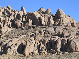
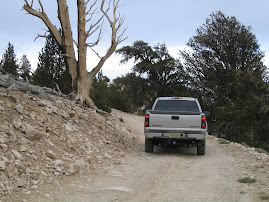
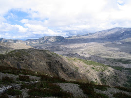
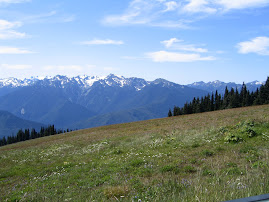
The ride up was great. The temp on the desert floor was mid 80's and at the top 42. Once we leave the pavement, it looks like a moonscape. The White Mountain area is in the shadow of the main Sierra range and extracts almost all available moisture. The Bristlecone forest and trees are amazing. They look more dead than alive. Some have lost almost all their bark and have only a thin strip left attaching the roots to the needles, yet still survive. The views back to the Sierra are breathtaking. The sun set as we exited the park. Unfortunately sunset is back to about 7:20, so our evening cruises are being curtailed. Driving at night is not my favorite thing. Anyone who gets near this neighborhood should consider a drive up. It's a scene you'll see no where else.
We had discussed running down to Joshoa Tree National Park because I believed that the Bristlecone Pines were there. Bristlecones are the oldest known living things on earth. A little research revealed that no Bristlecones are found in Joshoa Tree Park. Joshoa Trees are found there. Bristlecones are found mainly in the White Mountain area. They live in an environment where little competition exists. About 10,000 feet up with almost no precipitation. Some trees are over 4,000 years old with the Methuselah Tree at 4500 years old considered the oldest living thing on earth. This tree is not identified for fear of vandalism.
The ride up was great. The temp on the desert floor was mid 80's and at the top 42. Once we leave the pavement, it looks like a moonscape. The White Mountain area is in the shadow of the main Sierra range and extracts almost all available moisture. The Bristlecone forest and trees are amazing. They look more dead than alive. Some have lost almost all their bark and have only a thin strip left attaching the roots to the needles, yet still survive. The views back to the Sierra are breathtaking. The sun set as we exited the park. Unfortunately sunset is back to about 7:20, so our evening cruises are being curtailed. Driving at night is not my favorite thing. Anyone who gets near this neighborhood should consider a drive up. It's a scene you'll see no where else.
Friday, September 28, 2007
Kings Canyon
The drive up to Kings Canyon was the reverse of the night before with the lights on. We stopped by the General Grant Grove and saw some more huge trees. This one's base is over 40' in diameter and it's about 275' tall. From there it is a 32 mile drive to the End of the Road on a windy, edge grabbing lane. It's amazing people have been able to build some of these roads. Anyway, King's Canyon is just that; a long, steep canyon with King's River in the bottom. Boulders as big as houses litter the stream beds. More breath-taking views. It must really be something in the spring melts. We had lunch in the King's Canyon Lodge which is more like the Milton Inn before renovation than the Ahwahnee in Yosemite. We had a burger and talked to a disinterested lessee/operator who can't wait until Nov.1 to be out of there.
No ski areas up here. People from LA have to go to Mammoth, about a 6 hour drive, to find high quality skiing. To get to the other side of the Sierra Nevada we have to go south almost to Bakersfield, east, and then north on Rt. 395. Up to Lone Pine, our last Californian stop.
No ski areas up here. People from LA have to go to Mammoth, about a 6 hour drive, to find high quality skiing. To get to the other side of the Sierra Nevada we have to go south almost to Bakersfield, east, and then north on Rt. 395. Up to Lone Pine, our last Californian stop.
Thursday, September 27, 2007
Sequoia National Park
We set up in Visalia, an agricultural town in the San Joaquin Valley just west of Sequoia NP. On the way in we saw acres of corn, sugar cane, citrus fruits and huge and odiferous dairey farms. Once again, it's back into the Sierra Nevada Range which runs from north of Tahoe south about 400 miles to just north of Bakersfield and ranges from 40 to 60 miles wide. Mt. Whitney, the highest spot in the continental US is on the eastern border of the park. No east-west roads traverse it between the southern border and the northern road in Yosemite.
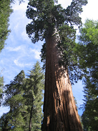
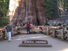
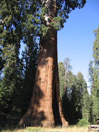
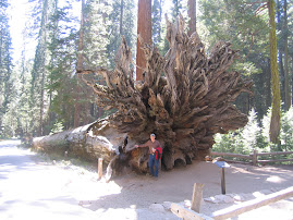
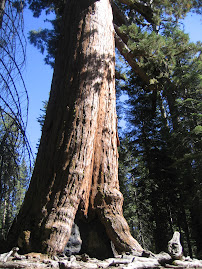
The road into Sequoia, like those into many of the parks, is a great ride. Road construction held us up a little, but we forged ahead to the General Sherman Tree, the largest known tree on earth. It's about 2,200 years old, 275 feet tall and 36.5 feet in diameter. The lowest limp is 130' up, and at 180' up the diameter is 14.5'. Experts believe that the grove where the tree lives offers optimal growing conditions for these trees. Annual growth is enough to grow an east coast tree of about 75', but since the top is dead, all growth is outward or in branches. The largest branch is 6' in diameter. It's quite a site.
On the way home we encountered a construction stop which they said would be a minimum of an hour. It was already 6:15pm, so I decided to turn around and us a different exit. It was 9:00 before we made it home.
Wednesday, September 26, 2007
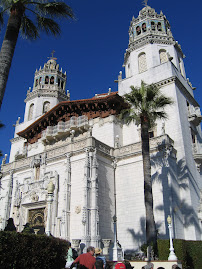
Hearst Castle II
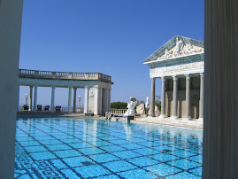
We went back for seconds at the Hearst Castle in San Simeon. Tour 2 included the upstairs of the main house and the kitchens. One upstairs sitting room /library was rimmed by Grecian Urns, some over 4000 years old. He had also donated half his collection of this type of art to a museum in LA. The tour guides are excellent and seem knowledgable not only about Hearst but about the vast amounts of stuff he accumulated.
After the tour, we found an ocean front place for an alfresco lunch. It was very good and we watched some surfers on smallish waves do their thing.
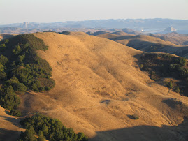
Heading back east on Rt. 46, the astonishing beauty of the California hill country was once again evident. It's breath taking.
After the tour, we found an ocean front place for an alfresco lunch. It was very good and we watched some surfers on smallish waves do their thing.
Heading back east on Rt. 46, the astonishing beauty of the California hill country was once again evident. It's breath taking.
Tuesday, September 25, 2007
San Simeon
We headed south and east to the town of Paso Robles, in the middle of the southern wine country of California. The vinyards line Rt. 101 for miles. Folks must be drinking way too much of that stuff. Mainly places you've never heard of. The RV park here is new and well laid out with adequate space.
We called and got reservations for an initial tour of San Simeon otherwise known as the Hearst Castle. Hearst and the Castle gained a lot notoriaty from Orson Welles' film, Citizen Kane, considered by many the best film ever made. As most films, it deviated from facts, and Hearst tried his hardest to ruin Welles after it's release.
The real Hearst was the son of George Hearst who made a fortune with a silver strike while looking for gold. He became the seventh wealthiest man in the country and bought some huge tracts of real eastate on the Pacific Ocean near the little village of San Simeon. Three or four hundres square miles with about fifty miles of ocean front. Hearst had become a major force in his own right with an empire of newspapers, then a major studio in the movie biz. He ran unsuccessfully for mayor of NYC and for governor of NY. Some people referred to the Spanish American War as "Hearst's War" believing that he had manipulated the situation to lead to America taking over Spanish holdings.
He had always loved the property on the Pacific. After his fathers death in 1919, he wanted to build but his mother was against it and he held off until after she passed away. He started in the 1920's and stopped in 1947 when his health made it necessary to be closer to medical facilities. He considered the project half done when he left, hoping to return and get back to work. He never did. Art work from around the world is everywhere. He had warehouses in NYC,LA and here to house all the stuff he bought in trips to Europe.
The Castle was donated to California by the Hearst Foundation. Because of the size, they give tours by sections. Yesterday, we took the Experience Tour which gave some history and took us through a guest house and the first floor of the castle. Today we will take a tour of the rest of the main house and maybe do one of the grounds. No drinks, no food, no gum no walking off the carpetted walkways, no leaving the group, no touching anything. A bunch of Nazis. But it's really something and it's run very professionally.
Hearst had five children with his wife, but then fell in love with Marion Davies, a movie starlet. His wife opted not to divorce, but instead bought a mansion on Long Island to live in and got herself a Spanish Nobleman to live with. The kids figured that when he died, they'd kick Marion out. But the will, the longest ever filed in California at the time, gave Marion 51% of the goods. She sold her position back to the Hearsts for $1 a year. Go figure.
Monday, September 24, 2007
Point Los Lobos and Big Sur
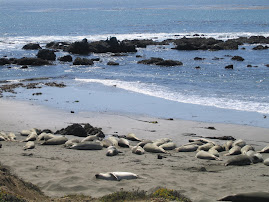
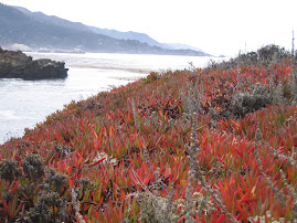
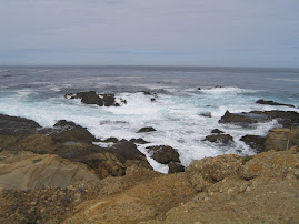
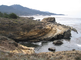
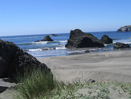
Two more beautiful ocean front spots would be hard to find. Both are California State Parks which charge $9 per car to enter. Los Lobos is really a gem. You park and walk paths along the shore. We saw seals, sea lions and sea otters. The sea lions are a hoot. There is constant chatter and positioning going on. The males seem to play a version of King of the Hill. There is always someone at the highest point on the rocks. The otters lay non their backs floating and cracking clams etc. with rocks they hold in their feet.
The ride south from there to Big Sur is spectacular. Will head south today and maybe see some of the Hearst Castle.
The ride south from there to Big Sur is spectacular. Will head south today and maybe see some of the Hearst Castle.
Sunday, September 23, 2007
Rain in Monterray?
Everybody around here is in shock. It just doesn't rain at this time of year here, especially during the Monterray Jazz Festival. Yesterday it did. Until 2:00 pm or so. We wandered into Carmel, the most upscale town we've been in yet. Art gallery after art gallery, one nicer than the next. Had lunch at the Hog's Breath, Clint Eastwood's little restaurant. He was once mayor here. Quite a beautiful place.
Drove down to Lobo's Point, but it was closing up, so we passed until today.
Drove down to Lobo's Point, but it was closing up, so we passed until today.
Saturday, September 22, 2007
Down to Monterray
The trip south to Carmel was uneventful and mostly highway. Our RV park is tucked away so far that it's amazing anyone finds it. After setting up, we decided to take the 17-Mile Drive, a ride laid out by the owners of the area, Peeble Beech Company. At one time I believe it was owned by the group of Arnold Palmer, Clint Eastwood and Peter Uberhoff. They still may. There are five golf courses on the pennisula, Spanish Bay, Spyglass, Poppy Hills, Cypress Point and Pebble Beach. The ride has a number of spots to pull over and view areas. Everything is first class and but low key. Very, very nice.
We exited the south gate and wandered through residential neighborhoods which go on and on. Some very interesting architecture in the area.
We exited the south gate and wandered through residential neighborhoods which go on and on. Some very interesting architecture in the area.
Friday, September 21, 2007
Sarah, Oliver and Haight-Ashbury
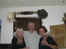
Sarah, David and Oliver Swain live in SF near the Golden Gate Park. Oliver is a 6 month old, blonde haired young man with quite a twinkle in his eye. He is having a very good time. We stopped by their home in early afternoon. David was at work downtown, so Sarah loaded Oliver up in a stroller and we walked out across the park and into the well known Haight -Ashbury section of town. Some of us remember it from the 60's as a happening place. It's very colorful. The streets are filled with shops of all types and a number of restaurants. We stopped at a little place for lunch that was excellent. Oliver is wide awake and attentive, trying not to miss a thing. By the time we got back, rush hour was approaching and we headed back out of town.
Today we move on to Carmel and the Monterray Pennisula.
Today we move on to Carmel and the Monterray Pennisula.
Thursday, September 20, 2007
Wine Country
We headed north from Novato to just south of Santa Rosa and headed west to Rt. 1 and the Pacific Ocean. We hit the ocean at Bodega Bay, the area made famous by Alfred Hickcock and his movie, "The Birds." ( The AMC channel has a seven day Hickcock special going right now, and when we got home "Vertigo" was on.) We drove north from there up to Stewart's Point. It's quite a ride; up hill and down dale, almost entirely on the ocean. We stopped for a picnic lunch, but had to eat in the car because it was too windy. We turned east at that point to head over to Healdsburg, a prominent wine country town.
To go east from the coast out here, you must go through the Coastal Range, a range of rolling hills and valleys about 20 some miles wide as the crow flys, but 50 following the road. The first section was through a near rain forest environement that broke into a redwood forest. A few old growth trees exist in this area, but not many. These zones are narrow and soon transcend into a drier zone of grass and scrub areas, and finally into the well known wine valleys of the area. As we came down into the Healdsburg area, vinyards were everywhere. It took about an hour and a half to cross the mountains and it was a beautiful ride.
We stopped at a couple of tasting stores to get some wine. The places are very professionally run. We ended up coming back south on Rt. 101 to our site. It was a very nice day.
Wednesday, September 19, 2007
Downtown San Fran
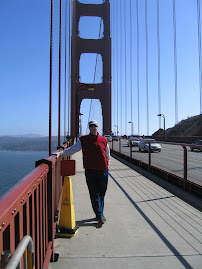
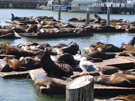
Sarah Swain set us an e-mail with a number of things to see and do while in SF and wine country. So we drove into town across the Golden Gate, turned on Lombard Street and followed it all the way down. This is the serpentine street you see in movies. The steepest section is one-way, covered in brick pavers and in a residential neighborhood. The speed limit is 5 mph and in a 20' truck that was about as fast as I could go. From there we drove past the Trans-American building in the financial district. Almost as narrow as the canyons of Wall Street. Went around a few corners and through the Gates of Chinatown, where we parked to shop for awhile. We then had lunch at The Empress of China restaurant. It was very good. We loaded up and drove over to Fisherman's Wharf and toured the area. The sea lions that failed to show up at Sea Lion Cave were all here, barking, snorting and smelling like sea lions. By the time we'd walked around there it was approaching rush hour, so we headed back north across the GG. We stopped at the north end and walked out to the first tower. Wind surfers were out on the bay in what felt like a gail wind.
Instead of going straight home, we got on Rt. 1, the old coastal road and headed north. What a windy, steep road that is. We made it up to Point Reyes National Seashore before heading back east to our digs in Novato. It was a great ride.
Instead of going straight home, we got on Rt. 1, the old coastal road and headed north. What a windy, steep road that is. We made it up to Point Reyes National Seashore before heading back east to our digs in Novato. It was a great ride.
Tuesday, September 18, 2007
The City by the Bay
We hauled over from Yosemite to San Fran yesterday. The ride was ok until we missed a sign and went into town over the Bay Bridge and had to zig through town with the RV behind, to the Golden Gate Bridge. That's way more harrowing than being on rutted dirt roads. We are parked in Novato, about 20 miles north of the bridge on Rt. 101. It's an urban RV park, but nice enough. We will explore for a couple of days and meet up with Sarah and David Swain on Thursday. Sarah is the daughter of my cousin Joe and his wife Cindy for those of you who don't recognize the name. They live in SF and have a young son, Oliver, less than 1 year old, but probably standing and getting around by now. We remember those days.
Monday, September 17, 2007
Addendum to Bruce's blog
By now you must know that the pilot and co-pilot have different ideas of fun--yesterday's back road trip was NOT FUN for the co-pilot. Find the narrowest,dirtiest,bumpiest,most rutted road in Sussex county, and then hang it off the side of a big mountain--that's what the Buck Creek etc. road was like!!! I will remember it, and how happy I was to be done with it. At least our lovely brunch helped temper the 2 hrs. prior!!!
Dirt roads and the Ahwahnee Lodge
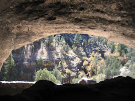
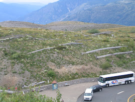
We headed over to Yosemite Park this am to brunch at the famous Ahwahnee Lodge. More about that later. Since we had not entered the park through the Arch Rock Entrance near El Portal, we wanted to go south to Rt 140 and enter there. At the National Parks, the entrances and exits are often the best rides. Since our RV park was on Rt. 120, and since no major north/south appeared on the map, I decided to try some lesser roads. We headed east on 120, then turned south onto Buck Meadow Road. It soon changed to dirt. It's been so dry out here that dirt roads are powdery and we left a trail of dust even at 15 to 20 mph. We were headed for Briceburg on Rt. 140 and had to take Bull Creek Rd. followed by Briceburg Rd. The road became narrower and narrower as we continued even though at about the half way mark there was an historic marker. Way back when a group of locals contributed and raised funds to build a public road to Yosemite, an act they claimed was unparalleled in modern times. We were heading steadily uphill and soon the road became filled with ruts and then deep ruts. Luckily, our big ol'truck was equal to the task. After miles of 5mph straddling ruts and switchbacks that were sharper and sharper, we arrived at a ridge top looking down into the valley where Rt. 140 leads to Yosemite. We must have been 4,000' above the road on as steep a hill as you can imagine. The road at this point was down to 10 or 12 feet wide, rutted and covered with talcom powder dust, and all switch backs. The switchbacks were wider and the only place a vehicle coming the other way could pass. At one switchback we encountered 3 motercyclists coming up. He said, "Great road, huh?" We contined our descent at about 5 mph. Both of us were happy to see flat land and blacktop at the bottom.
The ride in on 140 was scenic. The road had restrictions as a landslide had blocked the road at one point. They bridged across the Merced River and built a road there for about a mile and then bridged back to the main road. The landslide looked to be abour a quarter of a mile wide, but quite deep and extended into the river. The Arch Rock Entrance is just that. Both the entry and exit roads go under huge granite boulders which came to rest lodged on other boulders, creating a tunnel of sorts.
From there it was a short drive to Yosemite Village and the Ahwahnee Lodge. It was designed by Gilbert Stanley Underwood and opened in 1927. It's interior is Native American and spectacular. It boasts an AAA four diamond rating, whatever that is. They had a wonderful brunch, Sundays only. It was great. The best way to see Yosemite would be to rent a sporty convertible and stay a week at the Ahwahnee.
I wish our truck was convertible. In many of the parks, a roof is a huge detriment.
On the way home, we drove the 16 miles or so out to the Hetch Hetchy Reservoir. It was built after the SF earthquake and fires which destroyed the city. It required an Act of Congress since the area was already part of a National Park. John Muir, patriach of Yosemite, tried his best ot prevent it, claiming it was as special as Yosemite. It's beautiful, but no Yosemite.
A couple things missed over the last few days:
Glacier Point is the best view of Yosemite Valley, but the drought left almost all the waterfalls dry. The highest falls, Yosemite Falls at 2425' and Sentinal Fall at 2,000' were dry. Nevada Falls was the only substantial ones flowing.
Glacier Point also had two privately owned lodges near the over look, but they were burned by fires in 1969 and can not be rebuilt. That must have been an interesting discussion.
At about 7:45 am on Saturday, up near 8'000', our thermometer registered 26 degrees. It's so dry that no frost or dew drops.
Yosemite is unbelievable. Remember, rent a convertible.
Sunday, September 16, 2007
Bodie and Back
We planned an earley departure to drive across the northern Yosemite road to Tioga Pass and the NE entrance to the park. The traffic can get thick on weekends. We were out at 6:45 and on our way. The drive is spectacular. The views back across the valley are beautiful as are the constant granite outcroppings, domes and monoliths. At one point you can see back across the valley to the rear of Half Dome. It's about a two hour ride from our RV park to the Tioga Pass. We were by ourselves for about half the time and then hourdes of hikers started showing up.
We exited the park and drove to the intersection with Rt. 395 at Mono Lake. It's a large lake that was piped for some time for western California water and the levels fell and fell. Finally removing water was stopped, but the lake has not regained full level. It takes awhile at these elevations.
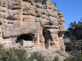
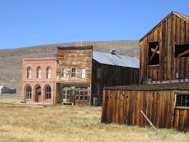
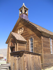
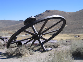
We had heard from Rosalyn Lynch that she and Brian had visited a ghost mining town named Bodie. It was about 30 miles outside of Lee Vining, a town on 395. We headed north for 18 miles and turned east on Rt. 270 to Bodie. It's in a state park off 3 miles of unpaved road at the end of 270. Bodie housed 10,000 people at one time and operated into the 1930's, so that steam powered equipment had been replaced with electric. In earley days it was a rough and tumble town known for gun fights and brawls. Much of it is preserved and some is being rebuilt. It's quite expansive with 25 or 30 buildings and out in the middle of nowhere at 8,000 of elevation. We enjoyed the walk around there.
Heading back on Rt. 270, we had a view of the Sierra stretching as far as the eye could see north and south and sprinkled with white patches of snow field and glaciers struggling to hold on a few more weeks until snows start.
We returned through the park and began looking for fuel. The first place west of Yosemite had gas over $4 and diesal at 3.98. Fortunately, near Groveland things were more reasonable. We filled up and then just missed the finale of a local chilli cook off. It was all gone when we got there.
We exited the park and drove to the intersection with Rt. 395 at Mono Lake. It's a large lake that was piped for some time for western California water and the levels fell and fell. Finally removing water was stopped, but the lake has not regained full level. It takes awhile at these elevations.
We had heard from Rosalyn Lynch that she and Brian had visited a ghost mining town named Bodie. It was about 30 miles outside of Lee Vining, a town on 395. We headed north for 18 miles and turned east on Rt. 270 to Bodie. It's in a state park off 3 miles of unpaved road at the end of 270. Bodie housed 10,000 people at one time and operated into the 1930's, so that steam powered equipment had been replaced with electric. In earley days it was a rough and tumble town known for gun fights and brawls. Much of it is preserved and some is being rebuilt. It's quite expansive with 25 or 30 buildings and out in the middle of nowhere at 8,000 of elevation. We enjoyed the walk around there.
Heading back on Rt. 270, we had a view of the Sierra stretching as far as the eye could see north and south and sprinkled with white patches of snow field and glaciers struggling to hold on a few more weeks until snows start.
We returned through the park and began looking for fuel. The first place west of Yosemite had gas over $4 and diesal at 3.98. Fortunately, near Groveland things were more reasonable. We filled up and then just missed the finale of a local chilli cook off. It was all gone when we got there.
Saturday, September 15, 2007
WOW
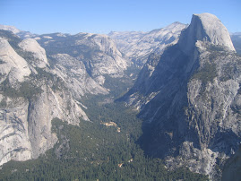
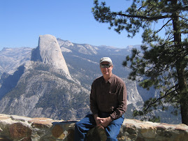
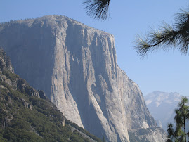
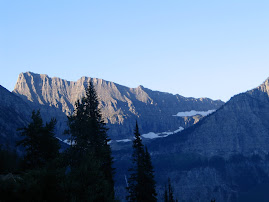
We drove out to Glacier Point in Yosemite Park yesterday. It set a new standard for natural beauty. The views down the valley, to El Capitan, the 3,000' tall granite monolith, and over Half-Dome are indescribable. The drive was very nearly in the same category. There was just a little haze, so we hope pictures come out. A guy who was guiding a small group had climbed to the top of Half Dome the day before with his father. When we were finished gawking at that scene, we continued south to the the Marisposa Grove of old growth Sequoias.
The lots were full, so we had to park 2 miles away and wait for a skuttle bus or walk. For some reason we thought we could walk 2 miles up hill at this altitude and we started out. Less than half way up we put out a thumb and were picked up by a good Samaritan. Once at the top, it was about a mile hike up into the grove where the largest trees stood. As we started a ranger was talking who getting ready to begin a guided tour. We waited and went with the tour. It was well worth it. The sequoias here were dated at about 1800 years old. Dating is not 100 per cent accurate. Sequoias are a little different from coastal redwoods. They are shorter, wider and older, and rarely grow a new tree from a stump sucker as redwoods do. The largest tree in the grove is the Grizzley Tree. It's only 209' tall, but over 30' in diameter. Immense.
By the time we walked and skuttled back down to the car we were walked out and exhilerated. It was a great day.
Friday, September 14, 2007
Yosemite
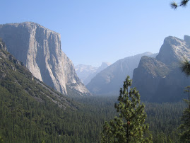
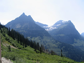
The drive from Tahoe to Yosemite is about 150 miles according to map quest. Most of it is on Scenic Byway highways and the ride was gorgeous. Took about 4 hours with the rig and we were on some mighty windy roads getting in here. The Yosemite Valley is tucked into the Sierra Nevada in a way that made it hard to find. The area is bone dry. The forest fire index is extreme. After setting up, we drove into the park. It is absolutely spectacular and amazing. The valley is formed by some of the highest and most severe granite outcroppings in the world. The views down the valley are dramatic. It's like entering a lost world.
We went to the visitors center to get info. Because of the valley's confinement, they have made a huge effort to reduce vehicle traffic and emissions which smog the place up. Free shuttle services are available and we may try them tomorrow. To discourage driving, they have limited parking and the parking available is a long way away from any services.
We went to the visitors center to get info. Because of the valley's confinement, they have made a huge effort to reduce vehicle traffic and emissions which smog the place up. Free shuttle services are available and we may try them tomorrow. To discourage driving, they have limited parking and the parking available is a long way away from any services.
Thursday, September 13, 2007
Sierra Nevada
We had a somewhat slow day yesterday, at least for awhile. We shopped, did laundry, changed a filter on the auxillary fuel tank, and cleaned the RV. Then Dana had a hair appointment and chatted with the stylist. She recommended we check out Gardnerville, Nv. We took Rt. 207 east up and over the mountains, once again going over the 7,000' mark. The drive over and down into the valley was great. It's one of those huge high plains valleys that the pioneers had to cross so that they could climb the mountains on the other side.
From there we went south on Rt. 395 until we turned back west on Rt. 89, a registered Scenic Byway. It was late in the day so the shadows and light were beautiful. The rest of the ride home was marvelous. The Sierra Nevada Range is rugged and bleak through these areas. Rainfall must be minimal. As we looked out over the hundreds of gullies and creak beds, we could imagine prospectors following the waterways up into the mountains looking for gold and silver. I believe the Comstock Load, the largest silver strike ever is near Carson City.
Off to Yosemite today.
Wednesday, September 12, 2007
Caught in the Pass
We took an extended trip around Tahoe. It has to be one of the nicest lake areas in the world. The east side is more developed in the sense that there are more services and stores in the towns there, and they are right on the lake. On the north side, the main road drifts away from the lake, so we took a turn into Incline Village and continued on the lake front. Beautiful homes and villages were tucked in there. At the NW side of the lake, we headed north to Truckee and the Donner Pass State Park.
At the Park we saw a film about the tragic events which occurred there in 1848. A group of pioneers got a late start crossing the Sierra Nevada and then ran into delays. They then ran into a winter the film claimed has not been surpassed to this day in severity. About 90 people were trapped by storms. They split into 3 or 4 separate groups to try to survive. One group chopped down trees to make a shelter. For years the stumps of these trees acted as a marker because the axe cuts were 22' up the trees. Provisions were inadequate so starvation and canabalism followed. Nobody was accused of murder. They ate the dead. Heroic rescue efforts were all thwarted by weather. By the time rescuers got there, only about half were alive. This pass is now crossed by I-80.
We continued south down the west side of Lake Tahoe. The homes become even more spectacular with many having private gates. I'd have to guess that 75 per cent of the shore line is developed with the rest being parklands. For those of you who haven't been here, the lake is basically surrounded by 7,000' mountains, almost like a huge Crater Lake. Many ski areas surround it, and judging by the number of boats and marinas, it's also a popular summer vacation spot. The altitude makes for comfortable summers and lots of snow in winter. We stopped at a couple of state parks on the way around to view the sites. It has to be added to the "I've never seen anything prettier" list, which is getting longer.
Tuesday, September 11, 2007
Into Tahoe
We drove over from Red Bluff yesterday where temperatures had been in the 100's. We woke up in Tahoe this am and temp must be below 40. It's really cold. We weren't finished up setting up until after 3, so we just took a quick lap around the lake. It is a thing of beauty. The east side is the towns etc. and the west side is more residential, and quite upscale at that. We hadn't been aware that there are casinos here, so we decided to hit the biggest one, Harrah's. It was a dump in what looked like a newer building. After wandering around the slots and tables, we looked at each other and exited.
Today we'll hit the visitors centers and see a little more.
Today we'll hit the visitors centers and see a little more.
Monday, September 10, 2007
Tahoe or Yosemite?
Don't know where we are going from here. The only important thing I had to do yesterday was call both places and see if forest fire smoke was at either. Between the Jets losing to the Pats and losing Pennington and the Giants losing to Dallas and losing Manning,Jacobs, and Umynera, my world went blank. Looks like the start of a very long season. At least in the individual sports arena, Federer and Tiger did what they do and won.
We were in a food store recently and saw lamb steaks, which we'd never seen before. Cooked them up on the grill and they were great. Best part of the day.
We were in a food store recently and saw lamb steaks, which we'd never seen before. Cooked them up on the grill and they were great. Best part of the day.
Sunday, September 9, 2007
Smoke Gets in Our Eyes
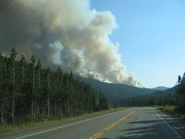
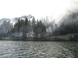
Moving east brought us once again into the arid and semi-arid lands east of the Cascades. Yesterday we tried to head north and a little east and ran into smoke from fires which were supposed to be in the northern areas of the state. Lassen National Park was our objective, but as we approached the park, the smoke became more oppressive. It began to remind me of the Glacier-Missoula area where it was really nasty. By the way, the Jocko Lake fire north of Missoula is still burning four weeks after we left. We headed back south to loop home and soon were out of the worst of the smoke.
Our RV park here allows vehicle and RV washing which most don't, so I took advantage and washed the truck and the roof of the RV. It was also Super Saturday at the US Open tennis championship, so we saw some of the action. If you saw any of the Federer-Roddick match, you saw some great tennis. Roddick played about as well as he could and was still taken out in straight sets. Federer looks unbeatable on any surface but clay and has reached 10 consecutive Grand Slam event finals.
Today was a planned downday. We'll do some chores, finish washing the RV and get excited about the Giants game. Eli's comin'.
Saturday, September 8, 2007
Into the Mountains
We left the coastal area and the big trees and headed due east to Red Bluff. The trip changed the climate from cool and humid to hot and arid. From 71 to 92. The ride was very pretty and the multiple ranges of northern Ca. beautiful and rugged. You'd never know that this state has over 36 million people, over half of which are minorities. It's a majority-minority state.
We'll be here for 3 days. Yesterday we ran up to Redding to see the Turtle Bay Park which got high reviews from some quarters. Today we'll go to Lassen National Park, a volcanic area. Tomorrow is a day off to clean vehicles and watch the New York Football Giants kick the hell out of the Bill Parcell-less Cowboys. That's a national game so we'll see it. The Jets-Pats would be lucky to have on TV out here.
We'll be here for 3 days. Yesterday we ran up to Redding to see the Turtle Bay Park which got high reviews from some quarters. Today we'll go to Lassen National Park, a volcanic area. Tomorrow is a day off to clean vehicles and watch the New York Football Giants kick the hell out of the Bill Parcell-less Cowboys. That's a national game so we'll see it. The Jets-Pats would be lucky to have on TV out here.
Friday, September 7, 2007
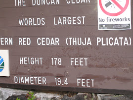
Avenue of the Giants
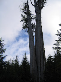
About 20 miles south of Arcata is a 33 mile section of old Rt. 101 known as Avenue of the Giants. It's a road through a large section of old growth forest with many spots to pull over and a number of trails through groves of Redwoods. It's claim to fame is that it's only about 200 miles north of San Fran and the nearest spot a traveler visiting there could go to see these trees. About the most spectacular thing we saw was the Dyerville Giant, a 362' tall, 17 feet in diameter, 1,000,000 pounds, 1600 year old bruiser that fell on March 24, 1991. It fell because another couple trees fell do to extremely wet soil and knocked it over. A person a mile away heard it and thought it was a train wreck. The trunk ran about 200' before the first limbs.
Redwoods at one time were found around the world, but climate changes have reduced the areas they thrive in to the California coast and a spot in China.
We came back on Rt. 101 which runs parallel to the Avenue, and from there, even though it runs right through the forest, you wouldn't know these immense trees are there.
Thursday, September 6, 2007
Flora,Fauna and thoughts
Time for more pictures--but first---Oregon is amazing-ithasrainforests,mountains,desert,rivers of great note, and of course the seashore. Love it all!! We've walked among redwoods with ferns as high as my shoulder,walked lava fields, and the beach looking for agates and sea creaturesand driven down silent green roadways. Our mysterious birds from days ago were ospreys which we have seen carrying fish as they flew by. We've seen sea lions on the rocks and in the water. Never thought anything could be as pretty as this coast.---------D.
More Big Trees
We left Gold Beach and headed down coastal Rt. 101 to the town of Arcata and set up camp. We then backtracked north to hit some of the points of interest in Redwood Park. A commercial attraction that has a gondola (like a ski lift) strung through trees was well adverised and we gave it a shot. Mystery Trees. The mystery is why they installed it in a grove of small trees. It was fair at best.
From there we headed back south through the park. The Lady Bird Johnson Grove was the best in show. About a 1 mile loop trail zig-zagging among gigantic old growth trees. They throw your sense of proportions off. It was spectacular.
From there we headed back south through the park. The Lady Bird Johnson Grove was the best in show. About a 1 mile loop trail zig-zagging among gigantic old growth trees. They throw your sense of proportions off. It was spectacular.
Wednesday, September 5, 2007
From The Redwood Forests...
Before I get going on yesterday, there was something omitted from the day before. After we set up our RV and Greg and Barbara left, we took a ride north on Rt. 101 to Bandon Dunes. For those of you not up on the golf scene, Bandon has become a golf Mecca over the last ten years. They have 3 courses, Bandon Dunes, Bandon Trails, and Pacific Dunes. They are all supposed to be superb. We walked to the rear of the Dunes clubhouse to a restaurant over looking the first tee. It was about 2:00pm and the tee had a constant stream of players teeing off. I don't know their fee schedule, but about $250 is the rate. Most people walk; some with caddies, some carrying their own bag. A few rode carts. The courses are all links style courses being right in the dunes. The wind blew relentlessly. Time for the ol' Long Island trap shot.
Lunch was excellent. Dana had their famous Bandon Cheese Burger and I had a Crab Melt. We wandered over to the pro shop for a look. The Ashworth Tech short sleeve mock turtles were $86. At any rate, everything here looks first rate and world class.
Back to the present. Yesterday we drove south to Brookings, Or., to a Chevy dealership to have some maintainence performed on the truck. Trans fluid, fuel filter, air filter. The brakes have 47,000 on them and the service guy said they still have 80 to 90 per cent of the pads left. They should last about 200,000 miles. Never heard such a thing. Had my second hair cut in 5 months at a salon. Shampoo, massage and trim. Took an hour and a quarter and cost $25. Never heard such a thing.
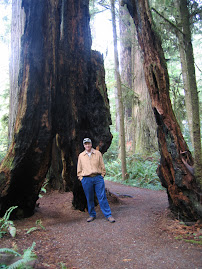
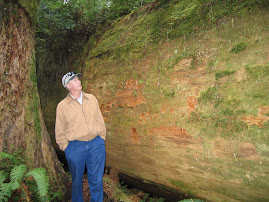
We then headed south to the main event of the day, retracing our path on the way into the area through parts of Redwood National and State Parks. The parks have a northern and southern section and we just did the north area for now. We stopped and took a walk through the Simpson-Reed Grove. It's difficult to find words to describe these things. They grow in an environment of 100" of rain per year plus many days of dense fog off the ocean which provides close to half of the tree's water needs. On sunny days, they transpire about 500 gallons of water. Some trees are over 300' tall and between 500 and 1,000 years old. They have shallow root systems (10-12 feet deep), but their roots intertwine with nearby trees to strenthen one another. The areas in the park are preserved old growth with ferns covering much of the ground between trees. It is really a site to see.
After leaving that area, we continued west on Rt. 199 to a Ranger station. We watched an educational film about the area and then stopped and talked to a Ranger. He suggested that we continue 2 miles east to the Stout Grove and then take Howland Hill Road SW back to Crescent City. The walk through the grove was great, but the drive on this little dirt road through an Redwood forest was unbelievable. It's like Alice in Wonderland. The narrow road twists and turns right next to trees that are up to 20' in diameter. No direct sunlight gets to the ground. We idled along at about 10 mph and just gawked at the scene. Joel's Dad, Jerre, once told me that the giant trees of California were the most awe inspiring things he had scene. He was right on the money.
Lunch was excellent. Dana had their famous Bandon Cheese Burger and I had a Crab Melt. We wandered over to the pro shop for a look. The Ashworth Tech short sleeve mock turtles were $86. At any rate, everything here looks first rate and world class.
Back to the present. Yesterday we drove south to Brookings, Or., to a Chevy dealership to have some maintainence performed on the truck. Trans fluid, fuel filter, air filter. The brakes have 47,000 on them and the service guy said they still have 80 to 90 per cent of the pads left. They should last about 200,000 miles. Never heard such a thing. Had my second hair cut in 5 months at a salon. Shampoo, massage and trim. Took an hour and a quarter and cost $25. Never heard such a thing.
We then headed south to the main event of the day, retracing our path on the way into the area through parts of Redwood National and State Parks. The parks have a northern and southern section and we just did the north area for now. We stopped and took a walk through the Simpson-Reed Grove. It's difficult to find words to describe these things. They grow in an environment of 100" of rain per year plus many days of dense fog off the ocean which provides close to half of the tree's water needs. On sunny days, they transpire about 500 gallons of water. Some trees are over 300' tall and between 500 and 1,000 years old. They have shallow root systems (10-12 feet deep), but their roots intertwine with nearby trees to strenthen one another. The areas in the park are preserved old growth with ferns covering much of the ground between trees. It is really a site to see.
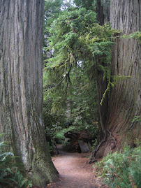
After leaving that area, we continued west on Rt. 199 to a Ranger station. We watched an educational film about the area and then stopped and talked to a Ranger. He suggested that we continue 2 miles east to the Stout Grove and then take Howland Hill Road SW back to Crescent City. The walk through the grove was great, but the drive on this little dirt road through an Redwood forest was unbelievable. It's like Alice in Wonderland. The narrow road twists and turns right next to trees that are up to 20' in diameter. No direct sunlight gets to the ground. We idled along at about 10 mph and just gawked at the scene. Joel's Dad, Jerre, once told me that the giant trees of California were the most awe inspiring things he had scene. He was right on the money.
Tuesday, September 4, 2007
Return to Reality
Once again we woke up and went down to the ocean first thing. It is so serene and beautiful. We called our children and my sister Carol from the beach. After picking up a few more rocks and a piece of drift wood for a souveneir, we climbed back to the house. Barbara and Greg had prepared bacon and eggs for breakfast. As we ate, the eagles and ospreys flew back and forth as if they knew it was time to perform. Amazing.
It was time for us to pack up and return to RV living. We went to our park and set up and Greg and Barbara stopped over to check out our operation. The fifth wheel is pretty nice but an awful long way from their place.
The stay at their place has been a real treat and their hospitality gracious. It was a really wonderful time.
Cliffhanging
We woke up in the morning and took the tram down to the house and then the path and stairs down to the beach. The last section down is a steep set of aluminum stairs. We went by the tree with the rope around it which served as beach access prior to the installation of the stairs. The beach has huge boulders spotted about along with some smooth sections. It was low tide, so we were able to get on the ocean side of some rocks where tidal pools exist. We found a spot covered with star fish of several colors. Orange and purple mainly. Anemone are everywhere. Beaches here are also covered with smooth rounded stones and much drift wood. Greg has several drift wood sculptures set on the grounds and Barbara has found many agates, which are transparent or translucent stones. The neighboring houses are much higher and back further from the ocean than Greg's. A massive rock outcropping just below the house created the spot lower and closer that they built on. Seals are sunning out on one of the ocean boulders.
When we climbed back up to the house, Greg and Barbara had coffee and bagels ready for breakfast. As we ate, once again eagles and ospreys flew back and forth, sometimes with fish in their tallons. One could easily spend the day just watching the flow of events outside.
Greg has a project going. On the upper level next to the studio, there is a spot which, once some clearing of scrub trees and brush occurred, afforded a view line out to a small island off the coast. He had built a cement block support for a concrete bench, which he had formed and poured. A local contractor friend, Tim, was going to stop over with a skid loader with forks, to set it in place. The bench was reckoned at 700 pounds. Greg wasn't sure exactly when Tim would arrive.
Dana and I set off on a drive up the Rogue River, the main attraction in town. It's a big salmon fishing spot. We went up the north side of the Rogue and made a first stop at the Tu Tu Tun Lodge, a spot which was just awarded the "Best Small Lodge" prize for the second year in a row. We hoped to have lunch but they are not open at lunch to the public. Folks staying there can have lunch prepared by ordering in advance. The lodge is beautiful with a lot of neat spots to relax and view the river. We continued a little further up stream and crossed the river at the Lobster Bridge and returned to the coast on the south side. We stopped back in town and picked up a deli lunch which we ate on the Pacific Beach a bit south of town.
A little after we got back to Cliffhanger, Tim showed up with his skid loader. I went out to watch and help the process. The bench was on blocks in the garage and Tim slid the forks under and brought it outside. In a very slick operation, the bench was soon set with mortar and properly positioned. Greg has had topsoil delivered and will build a berm which will hide the bench from the driveway. As you walk toward the view to the ocean between several berms, the bench area will reveal itself.
We all changed and headed over to the Riverview Restaurant on the south side of the Rogue. We enjoyed a very good meal. By the time we returned home it was time for bed. After Greg and Barbara headed down the tram, Dana and I wandered over to the new bench. It was a clear, dark night. Out here, there is no ambiant light and the stars were vivid and bountiful. It's been a long time since we've seen so bright a sky.
Monday, September 3, 2007
Gold Beach
We picked up and left Crater Lake heading to the coast and Gold Beach. My brother-in-law Mike Empson's brother lives there in a home he built on a bluff above the Pacific Ocean. He and his wife, Barbara, invited us to stay with them for a couple of days. The trip down was longer than expected because no roads run anywhere near directly through the Coastal Range. We had to angle sw down to Rt. 101 near Crescent City, Ca., and then go back north on 101. The drive was great as we passed through Redwood National Park. We will return there for a stay as we head south next week.
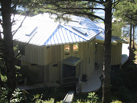
After dropping off the RV at a local place, we headed up to Greg and Barbara's place. It's down a little road a while with a gate that says "Cliffhanger" on it. The entry road curves in through thick undergrowth and trees to an opening on top of the hill. They have two single car garages with a studio/work shop on the second floor. Just ahead is the guest house. It has two sides connected by an open but covered breezeway. The left side has a garden room and the right side has two bedrooms which share an exceptional bathroom. At the front of the guest house central breezeway is a cable driven tram which descends to the front porch of the main house.
I could write quite awhile about the many features and views. It will have to be in a Housing Magazine at some time. Greg and a local builder designed and constructed the home and left no stone unturned. Greg continues fine-tuning with projects that he designs and builds. It is an amazing structure which was built into the natural features of the land. Everywhere a view to the ocean is possible is used. The rear of the home is a window wall which lends a panoramic view up and down the coast. Eagles fly by with fish. Ospreys abound. A deck wraps around the exterior and is built so that rails which would obstruct the view were unnecessary.
Greg and Barbara got us settled in and prepared a fine meal. We talked so much that we never took the path and steps down to the beach before dark. Greg and Barbara are both interested and engaged folks. In the two years or so that they've been here, they've gotten to know just about the whole town, and all their neighbors up and down the coast. We took the tram back up to the guest house and fell off to the beat of the waves on the beach.
Crater Lake Redoux
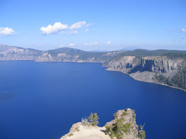
Well Crater was so pretty the first time that we decided to do it again. Once again we went around clock-wise , but this time we ran down to Klamath Falls when we hit the southern gate to the park. Wished we hadn't. When we got back to Rim Drive, we headed right in to the Crater Lake Lodge for a very late lunch. We started out with the NW Chowder and a salad and then moved on to risotto and beaf tid-bits. Quite fine. We walked out onto the porch facing the lake for the view of the century. It was a perfect blue-sky day and the water looked bluer than normal, which is saying a lot.
We stopped at a number of other overlooks on the way back. It is just a spectacular beauty.
We stopped at a number of other overlooks on the way back. It is just a spectacular beauty.
Subscribe to:
Posts (Atom)